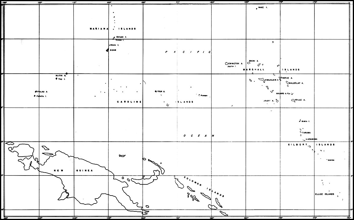
In November 1943, our forces were undertaking the final phase of the Solomons campaign, the reduction of Bougainville, and had progressed up the New Guinea coast as far as Finschhafen. Rabaul, the key Japanese position in that part of the Pacific, was under constant bombardment. On November 20, a third thrust against the enemy-held area was opened by our invasion of the Gilbert Islands. Chapter XXVII
Bases in the Central PacificTarawa, Makin, and Apamama, atoll islands, became the objects of our assaults in this opening move of a major offensive which was to carry us across the Pacific Ocean during the the year that lay ahead. The assault on Tarawa was bitterly contested, and casualties to the Second Marine Division ran high. Within four days the islands had been captured, however, and the key position of the Gilberts was in our hands. Immediately thereafter, three construction battalions arrived at the tiny atoll to build airfields for both fighter and bomber planes.
Army units made the landing on Makin, and although the island's defenders put up a belatedly stiff resistance, the position had been taken by November 22.
The landing on Apamama on November 24 met no serious opposition; on November 28 the 95th Battalion arrived to build an airfield.
Control of the Gilberts was only the first objective in the great Central Pacific offensive which had been put in motion. Next came the Marshalls group; at the end of January 1944, our forces moved against Kwajalein and Majuro atolls. After a terrific bombardment by carriers and battleships, on February 1 the Fourth Marine Division accompanied by the 121st Construction Battalion, landed on Roi and Namur, the northernmost islands of the Kwajalein atoll, while Army forces landed on its southern islands. By February 8 the entire atoll was in our possession. Four more construction battalions followed closely on the heels of the 121st; again, air-base construction became the first task after the assault period was over.
Landings made on Majuro at the same time found that atoll unoccupied by the enemy. A battalion of Seabees, the 100th, went ashore the next day to build a bomber field on one of the islands.
On February 17 our forces, moving still farther westward, landed on Eniwetok, and by February 20 its capture was announced. Engebi, the northernmost island of the Eniwetok atoll, was captured on February 18. Another bomber strip was put under construction within a week by the 110th Battalion, which arrived at Eniwetok on February 21.
Control of these strategic positions in the Marshlls was of vital importance. The by-passed Japanese garrisons at Mille, Wotje, Maleolap, and Jaluit were put in a position of helpless isolation. Moreover, the Japanese line of communication south from Wake Island had been effectively severed.
Great inroads had been made on the Japanese-mandated islands by our successes in the Gilberts and Marshalls. Ahead lay the important Marianas chain of islands. In the summer of 1944 the invasion of Saipan, Tinian, and Guam was put under way, involving some of the most important operations of the Pacific war. An account of the conquest and development of the Marianas is presented in Chapter 28.
Following closely upon the capture of the Marianas, Pacific Ocean areas forces moved to the west and south to attack Japanese positions in the western Carolines. Establishment of our forces in that area would complete the isolation of the enemy-held central and eastern Carolines, including the base at Truk.
Peleliu, in the Palau group of islands, was the point chosen for the first beach assault. On September 15, 1944, units of the First Marine Division went ashore. With two days the airfield, which
had been the prime object of the operation, had been captured, but thereafter enemy resistance stiffened and it was not until the middle of October that the defending forces were completely overcome.On September 17, Army forces landed on Angaur, 6 miles south of Peleliu. Opposition encountered was much less severe than that at Peleliu, and by September 20 the entire island had been over-run. Prompt steps were taken to develop a heavy-bomber field, to be used in the projected moves against the Philippines.
Control of the western Carolines was completed by the capture of Ulithi atoll on September 23. The Japanese had abandoned the position, and our landings met no opposition. Possession of the atoll gave us an extensive anchorage.
By this time the net was closing on the Philippines; Southwest Pacific forces were in complete control of New Guinea and had extended their strength as far west as Morotai by an operation coincident with the assault on the Palaus; the Marianas were in our hands and were already being developed as major Central Pacific bases; Rabaul, Truk, and Yap were isolated and neutralized. Recapture of the Philippine archipelago was the task that lay ahead.
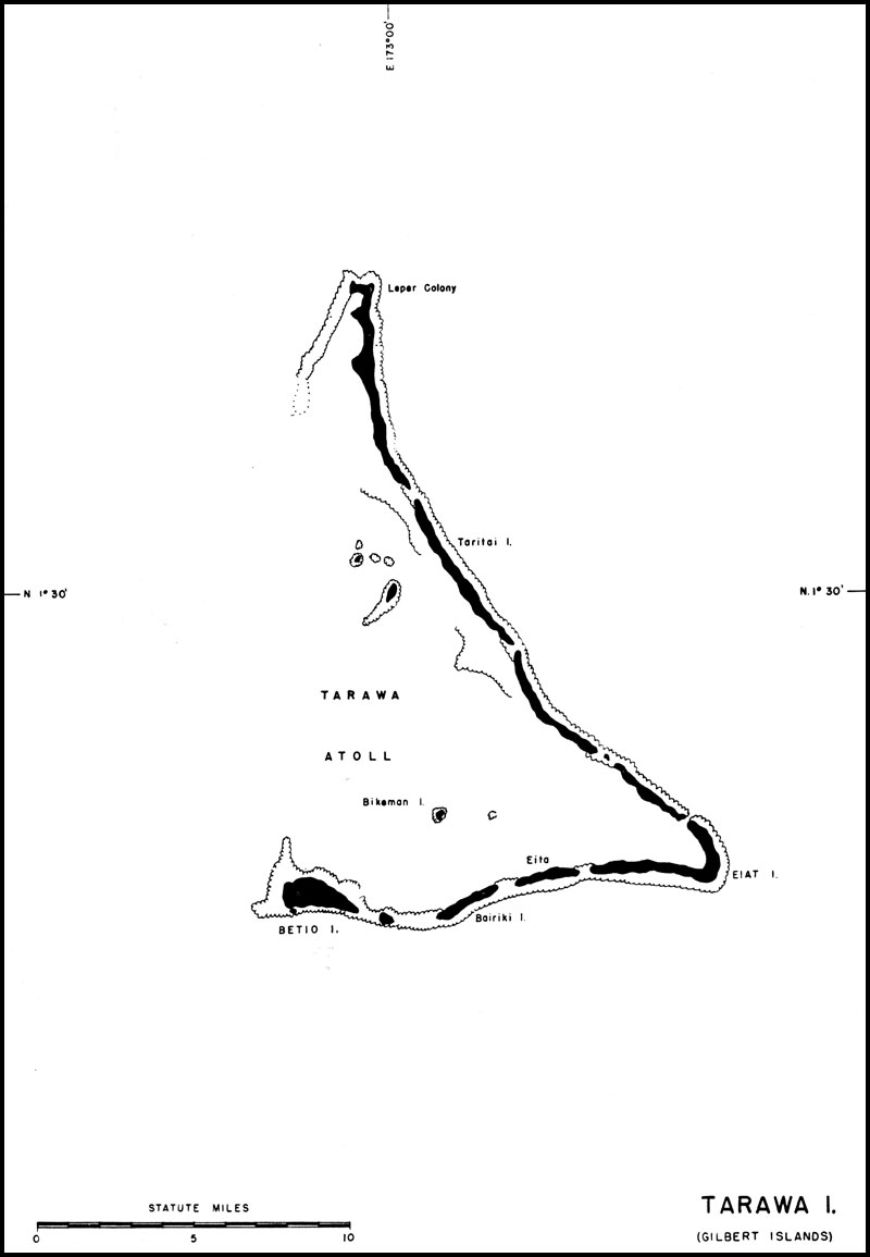
Tarawa, in the Gilbert Islands
See HyperWar for histories of the campaign in the Gilberts. The Gilbert Islands, which include Tarawa, Apamama, and Makin, are a group of coral atolls lying athwart the equator. Formerly held by the British, they were seized by the Japanese at the outbreak of the war, a move of great strategic significance as they were in close proximity to islands in our possession and immediately south and east of important Japanese bases in the Carolinas and Marshalls. Bases in these islands, therefore, became essential steps in our movement toward Japan.
The assault on Tarawa on November 20, 1943, was bitterly contested. Heavily fortified, and garrisoned by several thousand Japanese troops on Betio, the principal island of the atoll, it had been attacked repeatedly from the air for weeks preceding the assault, and on the previous day had been heavily bombarded by surface craft. Although these attacks silenced the Japanese heavy guns, wrecked everything above ground, and killed approximately half the enemy troops, many dugouts, pillboxes, and bomb-proof shelters were still intact or usable.
The enemy was able to concentrate his forces beside the only beach where a landing was possible, and in spite of air and surface fire support, our casualties were heavy. The assault lasted nearly four days, at the end of which time the island was considered secure, although subjected to air raids and isolated sniper action.
During the remainder of 1943, Army and Navy planes based at Tarawa carried out repeated attacks on enemy holdings in the Marshall Islands and on Nauru, inflicting considerable damage on ships and shore installations.
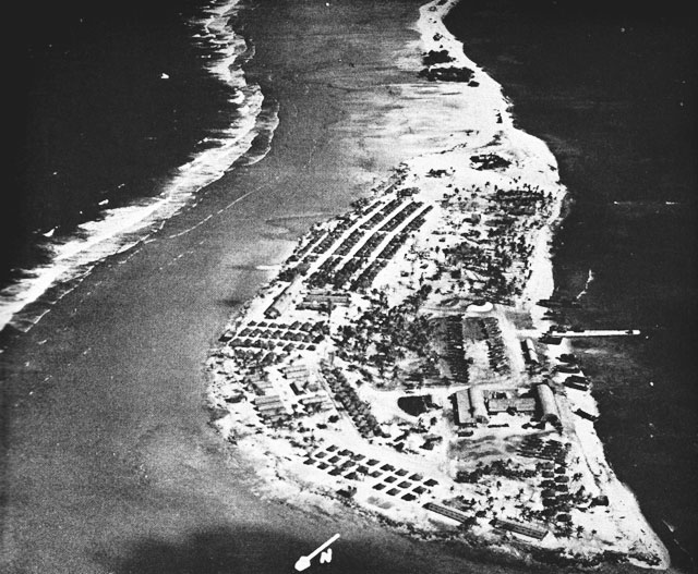
Tarawa, a triangular-shaped atoll, is composed of a series of island in a reef, covering 22 miles in length. The enclosed lagoon, about 17 miles long and tapering from 8 miles to less than a mile in width, is open to the west, though partially barred by a section of the submerged reef.
Betio, lying at the southwest corner of the Tarawa atoll, measures roughly 21/4 miles in length by less than half a mile in width. The reefs of Tarawa average 500 yards in width, the outer reef being about 2 feet higher than the lagoon reef. The beach is from 30 to 50 yards wide, rising only 5 or 6 feet.
Unforeseen wind and tide conditions uncovered the inner reef to such an extent that it became impassable to assault craft after the landing of the first wave. Ensuing waves were then forced to lie to under heavy fire or disembark their troops at a distance from the beach, in water so deep that wading ashore was extremely difficult. Heavy casualties and the loss of invaluable time resulted.
The first echelons of the construction battalions scheduled for Tarawa, the 74th and 98th, arrived in the lagoon November 24, 1943, D-plus-4, and advance reconnaissance parties went ashore as soon as the islands were declared secure. The 74th immediately began unloading LST's on Betio. The 98th, which was to perform the construction on Buoto Island, was held up on unloading until the final location of the airstrip was decided.
On November 27, a pontoon barge, which had been assembled on the ship, brought the first of the 98th's equipment to the beach. This equipment was used in the construction of a causeway to facilitate the unloading of the small boats and barges, and the work of clearing the fighter and bomber runways was started the next day. By the 29th, the entire battalion personnel was ashore except
Tarawa Atoll, Gilbert Islands
for a crew of 70, left aboard ship for stevedoring purposes.A temporary camp was established near the beach, and by December 8, the galley was able to serve the first hot meal. The permanent camp was begun on the other side of the island, but work was retarded through lack of manpower, all available hands being used to expedite completion of the airstrip. On December 4, the second echelon arrived to relieve the manpower shortage, and work on the camp went ahead.
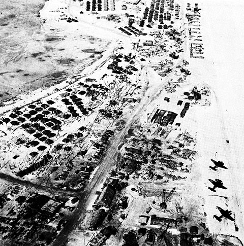
Airfield and Adjoining Facilities on Betio Island, TarawaThe early completion of an operational strip was the primary objective. By December 18th, or 20 days after work was started, a 4,000-foot fighter strip on the eastern end of the bomber strip was usable, and two days alter the first planes arrived.
Despite interruptions by enemy air raids, work progressed on the two strips. The taxiways and runways were surfaced with a 10-inch compacted layer of coral, mined from the lagoon below the level of high tide. In order to attain a more durable wearing surface, a coarse grade of coral, approximately one and a half inches in diameter, was worked into the top six inches of the original layer, providing an excellent runway surface. The completed bomber strip was 7,050 feet long with a surfaced width of 200 feet, and had 27 hardstands. The fighter strip was 4,000 feet by 150 feet and had 18 hardstands. More than 6,000 feet of taxiways were built, leading to an additional 25 hardstands.
Besides the landing fields and their own camp, the 98th built all the necessary housing and living facilities for 1,300 men of the unit which operated the field, a 100-bed quonset-type hospital, ammunition and bomb storage, a control tower, an aviation-gasoline tank farm of 500,000 gallon capacity and ready tank storage of 20,000 gallons. They also moved 30,000 cubic yards of coral fill in the construction of a 2,200-foot causeway at the western end of the landing field.
When the 74th Battalion went ashore at Betio, by far the most heavily defended island in the atoll, organized resistance had ceased, although many snipers were at large, and groups of Japanese were barricaded in underground shelters and in block-houses.
The greatest obstacle to be overcome was the condition of the island. As a base, it had been wrecked. Chaos, ruins, a litter of corpses and decaying food dumps extended over the entire 285 acres. Flies and mosquitoes, with ideal breeding conditions, existed in countless swarms; all water sources were brackish and polluted, with only salt water available for washing purposes. The menace to health was immediate and alarming, and it was little short of miraculous that no epidemic broke out, although dengue and dysentery appeared. The battalion lost no time in correcting these conditions.
Although no casualties were suffered by Seabee personnel, there was air raid damage to installations, stores, and equipment. Vehicles were burned or destroyed; others were perforated by bomb fragments, which also did considerable damage to tents; and heavy tire damage was caused, not only by the actual explosion of bombs, but by sharp fragments which littered roadways and the strip.
Literally every square foot of the island had to be cleaned, cleared and graded in order to begin with the installations and improvements. The necessity of unloading supplies on the tidal flat required a disproportionate number of men and created serious maintenance problems due to the exposure of equipment to the corrosive effect of sea-water and to damage from coral entering working parts. Carryalls and tractors were similarly damaged when removing coral from the reef. All
Central Pacific Area
grading and excavating work was rendered hazardous by buried mines and unexploded shells, as well unpleasant by the decomposed bodies frequently uncovered. In the latter connection, Seabees were used extensively as burying details for both enemy and American dead.Almost as soon as heavy equipment was ashore, the 74th went to work on the enemy airstrip. The existing installations consisted of an air base with all necessary appurtenances. The strip was 4,400 by 150 feet, surfaced with coral concrete of an average thickness of two inches, underlaid with a poorly compacted coral fill. It was relatively undamaged by the bombardment and assault, and temporary repairs made it possible for a squadron of fighters to land fifteen hours after the first Seabees went shore, and to operate continuously thereafter.
Six days later, six medium bombers landed and commenced patrol operations. The wheel loads of these planes proved so much greater than those of Japanese aircraft that the concrete strip surface began to fail rapidly and was condemned. It was removed and replaced, half the width at a time, continoues flight operations being maintained on the remaining half, and on December 17, 1943, twelve B-24's were staged through the field. Existing hardstands and taxiways were used and were later enlarged and augmented.
When the strip was completed, it was 6,600 by 400 feet, and totally coral-surfaced. The original schedule planned the strip to be operational for B-24's by D-plus-45; the 74th bettered this date by 18 days.
Aside from the air strip, the only Japanese installation of any value was a badly battered, coral-fill quay. It was repaired, but was so unstable that it could be used only for foot traffic and jeeps. As soon as manpower was available, work was started on a 1900-by-32-foot wharf. As there was no timber available for piling, it was necessary to use the rails from an abandoned narrow-gauge Japanese railroad. These piles were braced with Japanese reinforcing rod. Pierced plank was attached with wire to the rails and rods, and sheathed on the inside with light corrugated iron. The resulting structure was then filled with compacted coral.
Additional work of the 74th included housing and messing facilities for aviators and ground crews, and a tank farm of twelve 1,000-barrel tanks with two ready-gas stations, 7,200 feet of buried pipe-line, and 4,500 feet of submarine line for the handling of aviation gasoline. One of the larger Japanese bomb shelters was cleaned and renovated for use by the Medical Corps as an operating room and as shelter for patients during air raids.
The water supply was obtained from evaporators, and 19 wells producing brackish water were drilled to supply them. Evaporators with a total daily capacity of 20,000 gallons were installed and two 15,000-gallon and four 5,000-gallon wood-stave storage tanks erected, together with 7,000 feet of underground pipe-line.
In addition to high-priority jobs, other important construction and maintenance work was subsequently carried out. Surveyors, who had preceded the construction gangs under hazardous conditions, located important sites on Betio and the adjacent islands and made maps of them. Communications, power and light, and refrigeration facilities were built, together with all construction necessary for base operation.
After adequate living quarters were set up, they were improved by additions necessary for morale, such as a post office, theatre, and ship's service. Stevedoring work was aided by native labor, which had been returned to the island and which proved most satisfactory.
Considerable work was done in converting enemy equipment to our own use, as well as salvaging our own worn-out and damaged equipment. A small but effective detail was assigned to diving and salvage. This group recovered equipment and removed obstacles from the ocean floor and on several occasions examined and reported on hull damage to ships. Another group carried out extensive demolition work ashore.
The Seabees worked in close and friendly cooperation with the occupying force of Marines, each making use of the others' equipment and facilities until the departure of the 74th on March 1, 1944.
Apamama Atoll, in the Gilbert Islands, was occupied and developed as an air base simultaneously with other islands of the group, Tarawa and Makin, and for the same reasons. The atoll, approximately 15 miles long and 6 miles wide, contains a large, well-protected lagoon with an extensive anchorage area. The islands of the atoll have an elevation of about 12 feet, the soil being soft on the sea side Apamama, in the Gilberts
but firmer on the lagoon side, consisting of coarse loosely packed sand.The initial landing on Apamama was made November 24, 1943. The 95th Battalion followed on November 28, after minor enemy resistance had been overcome, the task being to build an air base.
A 4,000-by-150-foot fighter strip, O'Hare Field, was ready December 10, and the first plane landed on December 13. Extension to 6,000 feet for bomber operations was accomplished by December 21. The 95th Battalion continued the development of the field until March 1944, when CBMU 557 reported to relieve the battalion. At this time, installations at O'Hare Field consisted of a 7,700-by-200-foot coral-surfaced bomber strip, with an additional 1,950-foot sand strip; 21,000 feet of taxiways, with 100 coral-surfaced hardstands, 125 by 150 feet; and quonset huts for ready rooms and repair ships. The final aviation facilities were greater than planned, as the location proved of strategic importance for bombing missions to adjacent Japanese bases in the Gilberts and Marshalls.
The Seabees also constructed 19 miles of coral-surfaced roads, a 12,000-barrel tank farm with a 5,000-foot submarine pipe line, and a causeway to serve an as access pier for unloading and making minor repair to LST's and smaller craft. Storage space was provided by six prefabricated huts; quonset huts were erected for hospital facilities, offices, and work shops. Personnel were housed in tents.
The total number of natives employed at the peak of construction operations was 426. They proved entirely satisfactory as unskilled workers if sufficient supervision was provided. They were used extensively in the handling of cargo on the beach, and for procuring and placing coconut logs for pier construction. There was an abundance of suitable coral for airstrip and road surfacing, although the source was available only at low tide.
During the construction period, there were four minor air raids, resulting in the loss of one B-24 and slight damage to taxiways and hardstands. Neither the terrain nor the weather presented any obstacles to construction.
By May 1944, Apamama had definitely become a rear base, its mission of supporting the campaigns in the Marshalls completed. CBMU 557 continued maintenance operations until the fall of 1944, when the base was decommissioned.
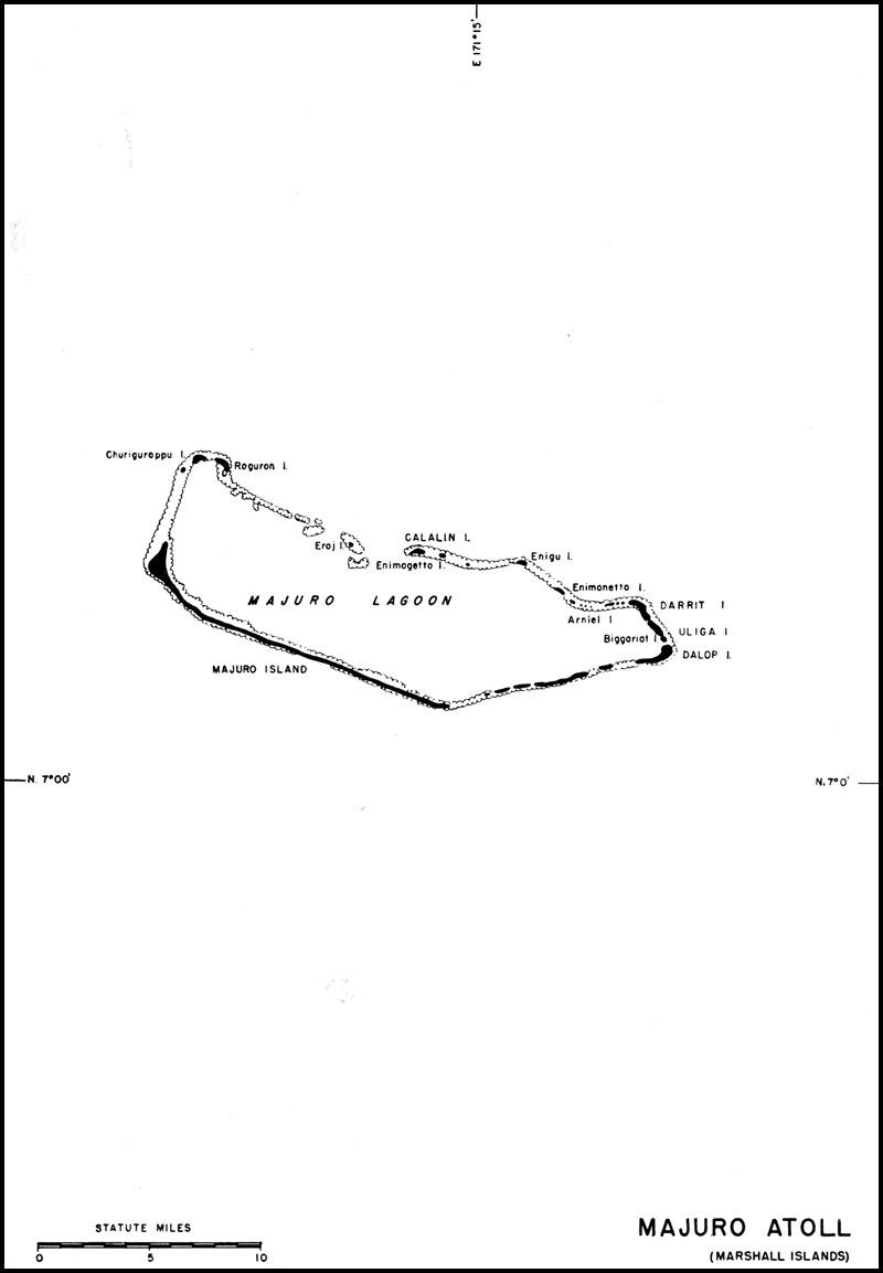
Majuro, in the Marshall Islands
See HyperWar for the campaigns in the Marshalls. The naval base at Majuro Atoll was established to support two Marine dive-bomber squadrons, half a patrol squadron, and temporary staging for one Army fighter group. In addition, it was to provide Naval Air Transport Service requirements, fleet anchorage without shore-based facilities, medical facilities, and a loran transmitting station. Repair ships, submarine and destroyer tenders, together with tankers and supply ships, were to provide for the needs of the fleet.
Majuro Atoll, in the Marshall group, consists of 56 islands, of which Majuro Island, at its western tip, is largest. The airstrip occupied the major portion of Dalop Island, on the eastern tip, and Uliga and Darrit Islands contained the base facilities, camps, and Port Director's area.
The surfaces of these islands are covered with coral sand which in some places had acquired a topsoil through the decay of vegetation. Rainfall is heavy, and the climate tropical.
Within the lagoon, depths run from 25 to 35 fathoms, with variable sand and coral bottom, relatively few coral heads existing other than in the western portion. The channel approach contains ample depth for the largest ships, and sand beaches afford excellent small boat and LST beaching areas.
Army assault forces landed on January 31, 1944, and found the atoll unoccupied. The 100th Construction Battalion followed on February 1, together with the first echelon of a Marine defense battalion.
Darrit Island had once been occupied by the Japanese, who left a 400ft timber pier, a narrow-gauge track from the pier leading to four frame warehouses, a seaplane ramp, and two steel buildings. At one end of a cleared area a large concrete slab had been poured for a hangar and structural steel was stacked nearby, from which a warehouse was constructed. A frame building, located between the pier and the seaplane ramp, became the harbor captain's office. Several food-storage buildings in the vicinity were also utilized. Large frame native worker's barracks became the maintenance shop building. Other barracks were made in to quarters for transients and a hospital; a seaplane hangar was converted into a warehouse; and smaller Japanese construction was used for various purposes.
On Dalop Island a coral-surfaced airstrip, 5,800 by 445 feet, was constructed. This was used on D-Day-plus-12 for an emergency landing, and by
Majuro Atoll (Marshall Islands)
April 15, the airfield, taxiways, aprons, housing, shops, and piers, as originally planned, were completed. Additional construction included 10 miles of coral roadways and 11,000 feet of 30-foot coral causeways connecting various islands.Acorn 8 dispensary, located among former Japanese quarters, was increased by the erection of Quonset huts and tents, its final capacity being 150 beds. Fuel-storage facilities were confined to gasoline-storage tanks; aviation gasoline storage was twelve 1,000-barrel bolted tanks set up on Bigariat Island, connected by 4-inch pipes to the underground ready-gas tanks at the airstrip. Delivery to the tank farm was by tanker, through a sea-loading line.
Water was supplied by distillation, the 21 stills used for this work producing about 50,000 gallons per day. Storage tanks for fresh water included 25 wooden tanks of 160,000-gallon capacity, four 12,000-gallon canvas tanks, and two 8,000-gallon cisterns. The water was distributed to various points by pipe line and tank trucks. A deep-water floating pier, 625 by 28 feet, was constructed, and unloading operations were further facilitated by nine 4-by-12-pontoon and four 3-by-7-pontoon barges.
Storage facilities erected, in addition to Japanese structures, were tents, tarpaulin-covered shelters, and 47 quonsets. Ammunition was stored in several underground magazines, in three Quonset huts, and in open-storage revetments.
Shop facilities were located in 17 Quonset huts and 6,000 square feet of tarpaulin-covered shelters. The administration buildings included ten Quonset huts and 81 tents, as well as the Japanese buildings remodeled for the purpose. On Calanin Island, at the entrance to the approach channel, a signal station and a harbor entrance control post were established.
Bomb-proof shelters were constructed at strategic locations, requiring a total of 350,000 cubic yards of coral fill. Fleet recreation facilities were also provided, all work being done by the 100th Battalion, supplemented in some cases by station personnel. The Seabee unit was housed in two tent camps, two companies living in the area adjoining the airstrip and the balance being based on Uliga, the main housing and administration area.
This construction was the work originally planned. The assignment of additional units to the base and the increased scope of activity necessitated considerable expansion.
Fourth Marine Air Wing headquarters and Marine Air Group 13 established at Majuro Atoll in the middle of March 1944. These units required the construction of two 750-man camps, shop and storage facilities. At the airstrip, it was necessary to build seven Quonset huts, a nose hangar, and several lean-to structures, and to increase hardstands and apron facilities. A utility air squadron was also assigned to Majuro and required the standard number and types of headquarters buildings, shops, nose hangars, and parking facilities.
When it was decided to locate the carrier replacement plane pool at Majuro, a strip, 175 by 4,000 feet, was cleared and paved on Uliga Island and a two-lane causeway connecting Uliga and Dalop was constructed, furnishing a 30-foot roadway. To accommodate air transport operations, a 150-by-800-foot apron was cleared and paved adjacent to the runway, with four Quonset huts to house office and storage facilities. Introduction of the plane pool activities demanded the doubling of carrier-aircraft service-unit personnel, and consequent enlargement of their living and shop facilities. The fleet recreation grounds and facilities were increased, and a submarine base recuperation camp was constructed which involved all installations necessary for a 750-man camp.
All facilities were used to capacity as numerous bomber and fighter squadrons operated from the airfield. The carrier-aircraft service unit serviced the fleet carriers, and the plane pool serviced and furnished replacement planes. The harbor was used as a fleet anchorage and fleet recreation center. The sorting of supplies, mail storage, communications, and personnel replacement taxed the remaining station facilities to the utmost.
Stevedoring duties were taken over from the 100th Battalion in February 1944, when Construction Battalion Detachment 1034 arrived in Majuro. This detachment of six officers and 250 men handled all cargo operations until August 1944, when they moved to Japtan Island in the Eniwetok Atoll.
The 60th Battalion performed all construction and maintenance work until relieved by CBMU 591 on June 18, 1944. The 60th left Majuro on July 5, 1944, for Pearl Harbor, CBMU 591 remained to take care of construction and maintenance. On V-J Day, all facilities were still operating at capacity, and no roll-up steps had been taken.
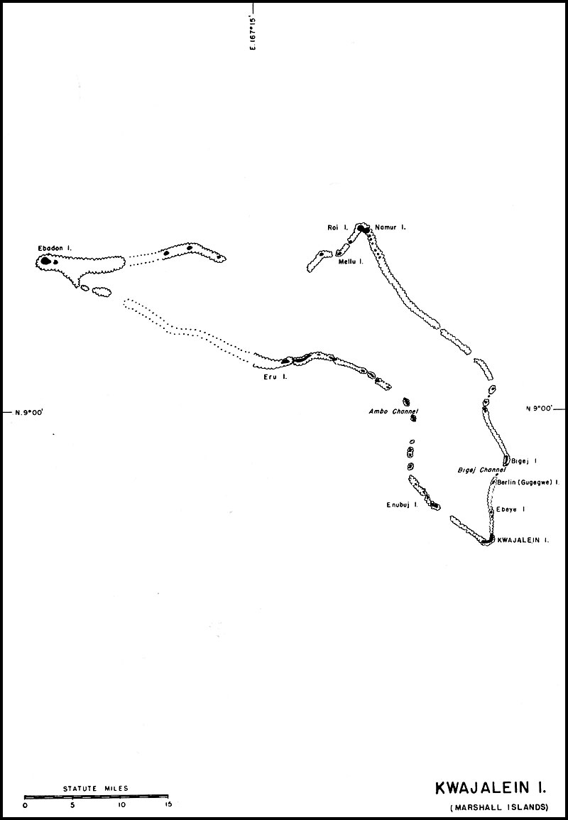
Kwajalein Atoll, in the Marshall Islands
To support air offensives against, and maintain surveillance over, the by-passed Japanese bases in
Roi-Namur in the Kwajalein Atollthe Marshalls and the Carolines, an advance air base, with minor fleet facilities, was established on Kwajalein Atoll, in the Marshall Islands. Complete facilities were to be provided for the operation of landplanes and seaplanes.
Kwajalein Atoll is 66 miles long and has a maximum width of 18 miles. More than 80 islands and islets lie along the partially submerges reef, which surrounds a lagoon of about 655 square miles.
Land areas large enough to be developed are found at only three points on the atoll, Kwajalein and neighboring islands at the southeastern end, Roi Islands and nearby islands at the northern end, and Ebadon Island at the western end. The southern islands are covered with a dense growth of coconut trees and smaller vegetation; the islands to the north are wooded.
The Kwajalein area includes Kwajalein Island and the islands on the reef for 12 miles to the north and 10 miles to the northwest. Ebeye Island lies 21/2 miles north of Kwajalein, and is separated from
the latter by an unbroken reef. It is 1770 yards long and 230 yards wide throughout most of its length. Kwajalein Island, crescent-shaped and open to the lagoon on the northwest, is about 3 miles long and varies in width from 1,000 to 2,500 feet.In the Roi area, considerable land exists only on Roi and Namur islands. Roi is 1250 yards long 1170 yards wide. Namur, to the east of Roi and connected with it by a narrow strip of land, is 890 yards long and 800 yards wide.
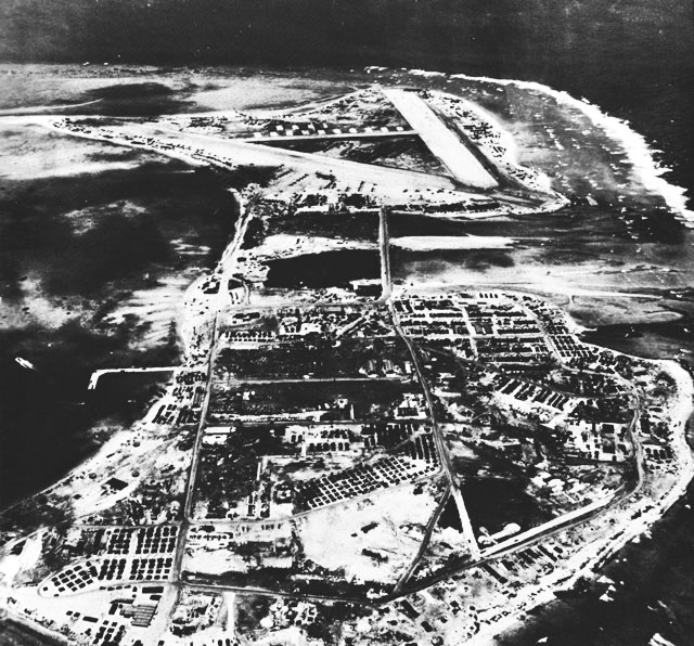
Kwajalein Atoll was highly developed as a military base by the Japanese. A major air base existed on Roi Island, and on Namur, connected by a causeway to Roi, were barracks, warehouses, a radio station, and a 450-foot L-shaped pier extending into the lagoon. Kwajalein Island contained many buildings, some of which were used as warehouses for a supply center. A 2,000 foot pier extended from the lagoon side of the island. An airstrip, 400 by 5,000 feet, had also been completed. Ebeye Island was the site of a seaplane base with hangars, two ramps, and an L-shaped pier.
On January 30 and 31, Kwajalein Atoll was subjected to heavy surface bombardment and air attack prior to landings by the Fourth Marine Division on Roi and Namur Islands and by the Seventh Army Division on Kwajalein, on February 1. The 121st Construction Battalion accompanied the first waves of Marines landing on Roi and Namur, as shore parties for combat teams. By February 2, Roi and Namur had been secured despite strong Japanese counterattack on Namur. Kwajalein Island was under Army control by February 5, and the entire atoll was secured by February 8.
Roi and Namur. -- The uprooting of all vegetation and the almost-complete destruction of enemy facilities by the assault force caused a tremendous accumulation of debris. Before any progress could be made in setting up camp and storage areas, beach development, or airfield construction, it was necessary for the 121st to remove the debris as quickly as possible.
On February 5, the battalion was ordered to consolidate and begin work on the Roi Island airfield, the 109th Battalion arriving the next day to assist on the project. The 121st, which was attached to the Marine division, had only 20 per cent of its equipment; consequently, the major portion of the heavy construction fell upon the 109th.
Of the three Japanese oil-surfaced airstrips, the runway, measuring 300 by 4,300 feet, was the first to be reconstructed. The existing strip was ripped up and resurfaced. The first fighter squadron arrived on February 13 and operated from the base as construction continued.
By February 12, most of the Marine division had departed and the remainder, with the 121st Battalion, were preparing to leave. On February 13, Japanese bombers launched a heavy attack against Roi, setting fire to a bomb dump. In the resulting destruction, the 109th Battalion suffered 102 casualties and lost 75 per cent of its material and 35 per cent of its equipment. The 121st's losses were 55 casualties, equipment was transferred to the 109th to help replace losses from the attack.
The 109th continued the airfield construction. The east-west Japanese runway, lately used as a storage area, was reconstructed by May 1944, with a 2,200-foot taxiway, and a concrete parking area was also provided. The third Japanese runway was then resurfaced for an additional repair and parking area. Including fighters, light bombers, and patrol planes, 100 planes were now based on Roi. The field was commissioned on May 15, and from it daily missions operated against Japanese installations on Wotje, Jaluit, and Truk.
On March 5, 1944, a detachment of 15 officers and 487 men of the 95th Battalion arrived on Namur, their major assignment being the construction of an aviation supply depot, which was commissioned on June 10. Roi was strategically located for use as a center to supply aviation materials to bombing missions against islands of the Marshalls and Marianas. Considerable amounts of supplies from this base also were used in support of the Marianas landings.
The 95th also erected a 4,000 barrel tank farm, with necessary piping; provided hospital facilities at three dispensaries, having a combined capacity of 300 beds; and erected housing accommodations of floored tents, Quonset huts, and barracks for all military activities.
As there were no deep-water waterfront facilities in the area, a 4-by-30-pontoon pier was assembled and a Japanese L-shaped pier, 450 by 33 feet, was used extensively to unload supplies from small craft. Repair installations consisted of overhaul shops for small-boat motors and a 4-by-15-pontoon
Kwajalein Atoll (Marshall Islands)
drydock for 100-ton capacity for aircraft rescue boats, picket boats, and LCM's. Connecting causeways and a perimeter road for each island were also constructed.Coral found on the islands was not of proper quality for use in surfacing, due to the large percentage of coarse sand, which resisted binding, consequently coral for surfacing purposes was taken from the lagoon. Native woods were used for minor construction, and native labor was employed on clean-up and sanitation details.
CBMU 590 arrived in June 1944 to relieve the construction battalions and continue maintenance.
Kwajalein Island. -- The 74th and 107th Battalions reported on Kwajalein Island in March 1944, the 74th setting up headquarters on near-by Berlin, or Gugegwe Island. This island had apparently been used by the Japanese as a supply base and for the repair of small craft. A marine railway with a capacity of 250 tons had been damaged by shelling, but was restored to usefulness for small-boat repair. A concrete pier, almost completed by the Japanese before our occupation, proved small but adequate, when finished for use of the boat pool. Berlin Island then became the site of shops for small-boat repair and overhaul, and of the Seabees camp.
A rock-crushing plant had been set up by the Japanese on Berlin Island and, although damaged, was salvageable for use in connection with the development of crushed coral for airstrip and road surfacing. The Seabees then rebuilt the existing Japanese runway on Kwajalein Island to provide a 6300-foot coral-surfaced strip with two 80-foot taxiways and 102 hardstands for heavy bombers. One hangar with minor aircraft-repair installations, was erected, and more than 12 miles of coral roads were built in the area.
Waterfront facilities were developed to provide minor fleet repairs. The Japanese pier was restored, and a 50-by-240-foot boat-slip was added to the outer end, forming an L. The depth alongside was 20 feet, and the pier could safely dock five LST's or a large number of small craft at one time. The Seabees also constructed a log crib, coral-fill quay, 300 feet long, with two 3-by-12-pontoon arms, and established repair facilities for landing craft. A 250-ton pontoon floating drydock was assembled, and a 2,000-ton floating drydock, capable of handling destroyer escorts, was provided for the base. Half the 15th Special Battalion was divided between Kwajalein and Roi-Namur for stevedoring.
Personnel were housed in floored and framed tents and in wooden frame barracks. Other base installations included the 200-bed 22nd Station Hospital, 80,000 square feet of covered storage, and a 12,000-barrel aviation-gasoline tank farm.
Between June and September 1944, the two battalions sent detachments to erect a large fuel-oil tank farm on Bigej Island, north of Kwajalein Island. This consisted of four 50,000-barrel tanks and fourteen 10,000-barrel tank, with all appurtenances.
CBMU 607 arrived in the area in August 1944, to relieve the construction battalions and take over maintenance and minor construction.
Ebeye Island. -- On March 7, 1944, four officers and 242 men of the 107th Battalion were sent to Ebeye Island to develop the seaplane base. As the two Japanese seaplane ramps had sustained only minor damage before their capture, construction work necessary for the development of the base, with the exception of paving the parking area and erecting shops and housing, was small.
In April 1944, the atoll commander was instructed to move his headquarters from Kwajalein Island to Ebeye. A detachment of the 74th Battalion was sent there to handle the construction necessary to the development of the headquarters, pending completion of the seaplane base by the 107th.
A Japanese pier, 1600 by 30 feet, with a 50-by-240-foot L extension, was repaired by the Seabees and a 250-foot Japanese H-shaped pier was also used. In addition, the Seabees assembled a pontoon wharf and pontoon barges for transporting damaged carrier aircraft to repair units ashore.
Further installations on Ebeye consisted of housing in floored tents and Quonset hut, a 150-bed dispensary, four magazines, 24,000 square feet of covered storage, and a 4,000-barrel aviation-gasoline tank farm.
Although the war moved far forward, no roll-up was contemplated at Kwajalein, as it was necessary to maintain aerial surveillance of the bypassed Japanese bases in the Marshalls and Carolines.
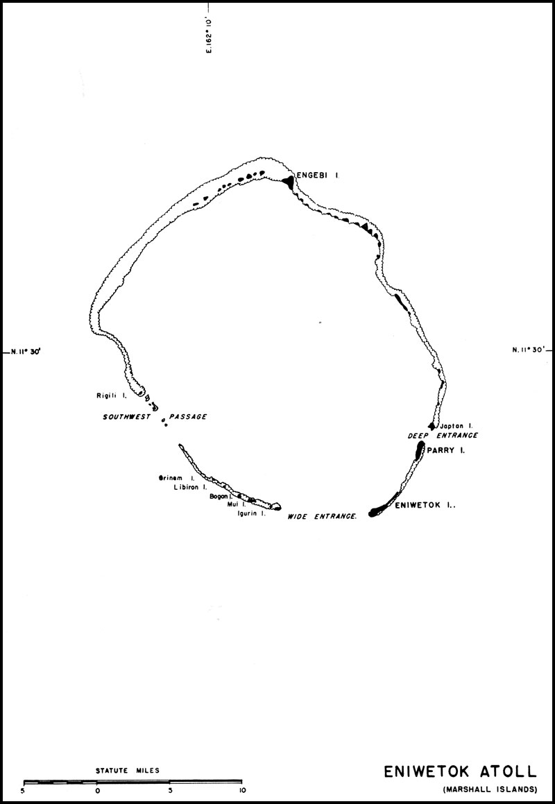
With the capture of Eniwetok Atoll on February 20, 1944, control of the Marshall Islands, which Eniwetok Atoll, in the Marshall Islands
had been in Japanese hands since 1914, passed to the United States. The atoll was to be developed principally as a Navy and Marine air base and a fleet anchorage, with no shore facilities other than a recreational area.Eniwetok Atoll, consisting of 30 small islands of sand and coral, lies about 326 miles northwest of Kwajalein. The circumference of the atoll is 64 miles and the maximum elevation is 15 feet. There are three entrances to the lagoon.
Eniwetok Island is two miles long and one-quarter of a mile wide. Engebi Island is triangular, each side measuring one mile, and has a good landing beach on the lagoon side. Parry Island is two miles long and very narrow, with a sandy beach on the lagoon side.
The 22nd Marines and elements of the 106th Infantry captured Eniwetok Atoll in a swift amphibious operation that lasted less than five days, landing February 18, 1944, on five small islands in the atoll, just southeast of Engebi Island. Engebi, forming the northern tip of the atoll, was the site of an airstrip, the most important installation on the atoll. Bombardment of Engebi continued throughout the day and night, and the following morning the assault began. Our forces moved rapidly inland, and the island was in our hands by late afternoon. While mopping-up continued in the northern section of the atoll, other Army and Marine units, on the morning of the 20th, landed on Eniwetok Island, the southeastern anchor of the atoll and the largest island of the group. By late the next morning, enemy forces had been eliminated. On the morning of the 22nd, our forces landed on Parry Island, site of a seaplane base, northeast of Eniwetok, and by evening that island also had been captured. No Seabee units participated in the initial assault.
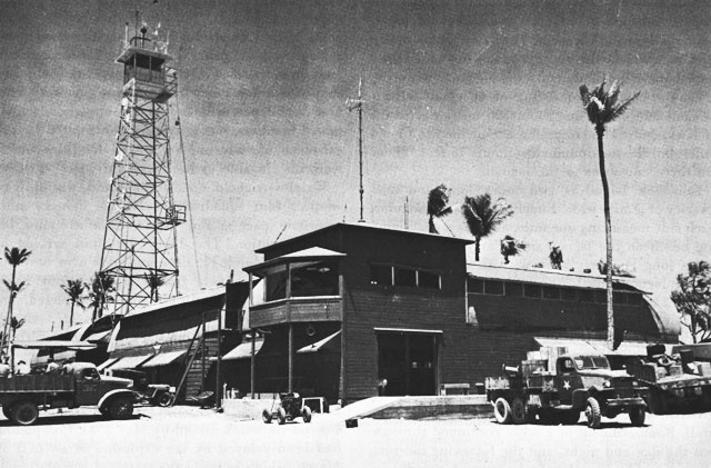
Echelons of the 110th Battalion arrived at Eniwetok between February 21 and 27, 1944, and immediately began clearing for a bomber strip. On March 11, the first plane landed and on April 5, the first mission by permanently based bomber squadrons was flown from Stickell Field. The completed field, 6,800 feet long and 400 feet wide, had two taxiways, facilities for major engine-overhaul, and housing for aviation personnel in quonset huts.
As activities increased, land area became insufficient to support these activities properly. To overcome this difficulty, quonset huts were erected atop one-story buildings, a measure which proved very practical.
On Parry Island, the 110th Battalion developed a seaplane base, using the existing Japanese ramp, and provided a coral-surfaced parking area, and shops for minor aircraft and engine overhaul. This base was capable of supporting one squadron of patrol bombers, but activities were limited by the eistence of only one ramp and by tides which were unfavorable to beaching activities.
Wrigley Airfield, on Engebi Island, was built to support four squadrons of Marine fighters until sufficient space at Eniwetok became available for their operation. The 126th Battalion arrived at Engebi on March 11, 1944, and took over development of this airfield from the 47th Army Engineers. Aviation facilities, when completed, included a fighter strip, 3950 by 225 feet, taxiways with 150 hardstands, and engine-overhaul shops.
A tank farm of twelve 1,000-barrel tanks, with piping, a floating pipe-line, 1,200 feet long, and a tanker mooring, was completed for aviation gasoline on Eniwetok Island by May 1944. Completion had been delayed by the explosion of an LCT in March, which reduced the status of completion of the farm from 80 to 30 percent. An aviation-gasoline tank farm, with a capacity of 146,000 gallons and all appurtenances, was also erected on Engebi.
Two coral-fill piers, one 80 and the other 150 feet long, were built on Eniwetok Island, and two beaches were developed for LCT's. Small-boat-repair shops were also built, and a floating dock for small ships was assigned to the base. At Parry Island, a marine railway was installed on an existing Japanese pier, and boat-repair shops were also erected. The Seabees repaired a 30-by-150-foot Japanese pier at Engebi, with timber piling, to accomodate small craft, including LCM's.
Medical facilities were provided by three dispensaries with a total capacity of 200 beds, one each at Eniwetok, Engebi, and Parry islands. Quonset huts and tents were erected for base storage and housing.
By June 1944, the major work projects on Engebi had been completed and CBMU 594 reported to take charge of maintenance activities. The 126th Battalion, pending its departure in October, was assigned to small projects on several islands in the atoll, including construction of a fleet recreation center on Hawthorne Island. CBMU 608 arrived in
Quonset Hut Variation at Eniwetok
Operations building, showing quonset huts erected atop one-story buildingsAugust 1944 to relieve the 110th Battalion, which left in September. The air base on Engebi was decommissioned on September 18, 1944, and by May 1945, all activities except a token garrison had been transferred to Eniwetok.
In June 1945, the 67th Battalion reported at Eniwetok, to build a fleet recreation area for 35,000 men and to extend carrier-aircraft service-unit facilities at Parry Island. V-J-Day found the 67th and CBMU 608 still stationed at Eniwetok.
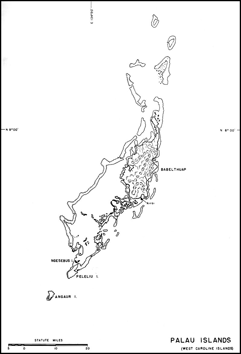
Palau Group, in the Caroline Islands
Guarding the eastern approaches to the southern Philippines, the Palau Islands were developed by the Japanese, in conjunction with Truk, into a powerful naval base. After the virtual neutralization of Truk by repeated Allied air attacks, the Palau Island replaced it as the principal Japanese advance naval base and assembly point for fuel, ammunition, and supplies moving between Japan and the southwest Pacific. The islands had also been developed as advance airbases to support light, medium and heavy aircraft, in the forthcoming Philippines operations.
The Palau Islands, which lie about 540 miles due east of Davao, are among the westernmost islands of the Carolines. The group is actually a complex atoll, made up of a cluster of volcanic islands, fragmented coral atolls, and islands of limestone composition, the whole surrounded by reefs. Peleliu and Angaur, at the southernmost tip of the group, were the only islands developed by our forces.
Angaur, 21/2 miles in length and less than 2 miles wide, rises 15 to 20 feet above sea level. The island is densely wooded, and the soil is generally coral limestone, so hard that it hindered construction. There is only one sheltered water area, a small boat basin on the western side of the island.
Eniwetok Atoll (Marshall Islands)
Peleliu is 51/2 miles long and 21/2 wide. The major portion of the land is low and level, but the central and northern portions contain numerous high rock ridges. Swamp areas, extending north and south, divide the island except for a minor strip on which its single east-west road is built. The coastline is mostly rocky but has about 2 miles of scattered sandy beaches.Although the Palau group offers a spacious and well-protected anchorage for major fleet elements, no major Japanese facilities existed for construction or repair of any except small craft. There were three airfields in the Palau group, the largest of which was located on Peleliu. A new operational strip was on the small island of Ngesebus, just north of Peleliu and connected to it by a bridge in the last stages of construction. A third field was still under construction at Airai, near the southern end of Babelthuap Island.
The Peleliu airfield, a cleared area at the southern portion of the island, contained two runways in an X pattern, one 3,900 feet and the other 3,850 feet long. There were two sizable service aprons, connected with each other, and with turning circles, by hard-surfaced taxiways. Good roads lined the northern coastal areas with the airfield.
Three days of surface bombardment and air bombing preceded the landing on Peleliu. During this time, mine sweepers cleared the waters of Peleliu and adjacent Angaur Island, and underwater demolition teams removed beach obstacles. The landing, on September 15, 1944, was made by units of the First Marine Division, Despite Difficult reef conditions, the initial landings were successful, and the troops quickly overran the beach defenses, which were thickly mined but less heavily manned than expected. By the night of the 16th, the Peleliu airfield, which was the prime objective of the entire operation, had been captured. After the rapid conquest of the southern portion of the island, however, progress on Peleliu slowed, as the rough ridge which formed the north-south backbone of the island was a natural fortress of mutually supporting cave positions. Although these were surrounded by September 26, it was not until the middle of October that the assault phase was complete.
The 81st Infantry Division went ashore on Angaur Island, 6 miles south of Peleliu, on September 17. Beach conditions here were more favorable than at Peleliu, and opposition also was less severe. By September 20, the entire island had been overrun, with the exception of a small inland area.
Marines from Peleliu landing on Ngesebus Island, just north of Peleliu, on September 28, by a shore-to-shore movement, and light enemy opposition was overcome by September 29. Later, several small islands in the vicinity were occupied as outposts. From Peleliu and Angaur, the other islands were dominated; enemy forces were neutralized.
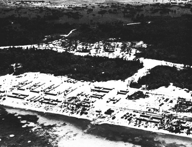
Three Seabee groups participated in the initial landing on Peleliu, the 33rd and 73rd Battalions and Construction Battalion Detachment 1054. On D-Day, the two construction battalion assigned men of the shore parties to assist in unloading supplies and ammunition and to aid in burying the dead. Unloading operations were made extremely difficult by the lack of harbors and the nature of the reef.
CBD 1054 operated the 24 pontoon barges with propulsion units. These pontoon barges were used extensively in the Peleliu invasion to transfer cargo between various types of landing craft, and to serve as floating dumps for high-priority cargo. On D-Day-plus-three, CBD 1054 installed pontoon causeways to the outer reef, and the next day the first LST was beached and unloaded over them. Causeway sections were also used to ferry loads of mobile equipment from LST's.
On D-Day-plus-four, the 33rd Battalion commenced removing land mines, duds, and shell fragments from the airfield, and when the first construction equipment came ashore the next day, it was immediately put to work filling shell holes and making general repairs. The strip was placed in operation 72 hours after the first equipment began work, when three squadrons of fighters arrived to support the remainder of the operation.
No Seabee units participated in the initial assault on Angaur. Army engineers immediately began the construction of a bomber field there.
On September 23, the 33rd Battalion began construction on Peleliu of a bomber strip, 6,000 feet long, with additional equipment borrowed from the First Marine Engineer Battalion and the 73rd Construction Battalion. Land mines were encountered, and during the first six days the field was subjected to mortar fire, but 24-hour air operation began on the seventh day.
Airfield development continued during the early months of 1945. When completed, the bomber strip measured 6,000 by 300 feet, and the fighter runway,
Palau Islands (West Caroline Islands)
4,000 by 250 feet. Taxiways and parking areas were constructed to support the assigned seven squadrons and 100 transient and cargo planes.The Seabees also erected four quonset-type warehouses for aviation shops, 20 quonset huts for offices and repair facilities, and complete camp installations for aviation personnel.
By January1945, the 73rd Battalion had completed a tank farm, consisting of one 10,000-barrel tank for motor gasoline, twenty 1,000-barrel tanks for aviation gasoline, and three 1,000-barrel tanks for the diesel oil.
Hospitals constructed by the Seabees were the 17th Army Evacuation Hospital and Navy Base Hospital 20. The former had a 440-bed capacity and was completed by the 73rd Battalion in November 1944. The 33rd Battalion then started construction of the naval hospital, and by the end of December, six H-type quonset-hut units, of 100 beds each, had been completed with all facilities. Due to delay in the arrival of materials, the 320-bed annex to Base Hospital 20 was not completed until March 1945. Numerous dispensaries, with a total capacity of 161 beds, were also provided for various naval activities.
By the end of January 1945, minor waterfront facilities were complete. The 33rd had rebuilt a Japanese concrete-block pier, which provided berths for three light craft. The approach channel was dredged to a 10-foot low-water depth and an LCT landing beach prepared.
The 301st Battalion, a harbor reclamation unit, was brought in to dredge access channels to a small boat basin, and to provide sufficient maneuvering
Naval Base Hospital 20, Peleliu
ORANGE Beach Causeway and Channel Entrance, Peleliu
Photograph taken May 22, 1945, shows Angaur Island in the left backgroundspace for small craft at all stages of the tide. A marine railway and shops for small-boat repair were built by the 73rd.
Stevedoring was handled by the first section of the 17th Special Battalion, with the assistance of crews from the 73rd Battalion.
Three major supply centers had been established by early 1945. Construction of the supply depot, begun by Army Engineers, was taken over by the 33rd Battalion in December 1944. Eight quonset-type warehouses, with concrete floors, were built for this activity. For the aviation supply depot, the Seabees constructed five quonset buildings. At the airfield, four 20-by-50-feet steel magazines were erected. The spare parts depot consisted of four quonset buildings, with concrete floors and unloading platforms, and several quonset huts for offices. More than 16 miles of primary roads were built to serve these activities on Peleliu.
Angaur was developed as an Army base, the airfield being constructed by two Army engineer battalions. Installations for the field were an airstrip, 7,000 by 150 feet, adequate taxiways, and hardstands for 120 planes. CBMU 532, which reported at Angaur in October 1944, assisted the Army by the erection of quonset-hut camps for aviation personnel.
The construction program for Angaur was not an extensive one. Detachments of Seabee units stationed on Peleliu were sent to Angaur to handle the erection of a tank farm, to assist the Army in the construction of the 39th Station Hospital, and to develop waterfront facilities.
During late 1944, the 73rd Battalion sent men to Angaur to build the tank farm, comprising twelve 1,000-barrel tanks for aviation gasoline, two 10,000-barrel diesel-oil tanks, and five 1,000-barrel tanks for motor gasoline. The existing phosphate pier was used to carry the pipe line for the tank farm. The project was completed by February 1945. A small boat basin was developed by a detachment of the 301st Battalion, just south of the
phosphate loading pier on the western side of the island, and the harbor was dredged to provide a minimum depth of 6 feet at low tide. A natural coral breakwater, forming the western side of the boat haven, was improved on the basin side by the construction of a concrete deck. Pontoon strings were used to form the southern end of the basin. This section was, in effect, a 70-foot pier which could furnish barge berths on the basin side.
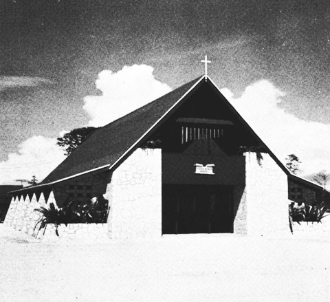
PURPLE Beach Chapel, PeleliuThe 73rd Battalion built boat shops and a 30-ton marine railway, 130 feet long.
At BLUE Beach, one officer and fifteen men of CBD 1054 were assigned to the construction of a pontoon causeway. The installation consisted of two single-pontoon strings, 150 long, placed about 150 feet apart at right angles to the beach line. A 2-by-30-pontoon string was then placed at right angles to the offshore end of the first two strings. The enclosed space was filled with coral rock, sand, and gravel, after all sections had been filled with sand and sunk. The pier was ready for use by LCT's on November 1, 1944.
In June 1945, the Army air base was abandoned. CBMU 532 took charge of dismantling and crating salvageable structures; they were secured on July 11, 1945.
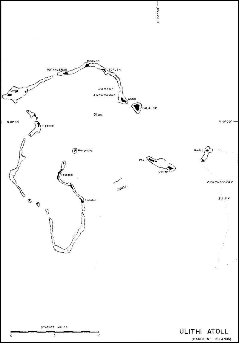
Ulithi, in the Western Carolines
The naval base at Ulithi was established to provide a fleet anchorage and an air base to support half of a night fighter squadron, a light inshore patrol squadron, a pool for a maximum of 150 carrier replacement aircraft, a utility squadron, and staging facilities for transport aircraft. The basic plan also called for maintaining shore facilities to support the garrison and the fleet.
This atoll, 93 miles northeast of Yap, 370 miles southwest of Guam, and 370 miles northeast of Peleliu, consists of four elements: the main atoll, in the west; the island of Falalop off the northeast point; a small detached reef with several islets, lying east of the main atoll; and Zohhoiiyonu Bank, an incomplete atoll, to the extreme east.
All the islets of the group are of typical atoll structure, with low level land, wooded in spots and swamp areas, generally covered with thick vegetation. The rainfall is heavy and the climate tropical. Mogmog Island, in the north, is the principal islet; others which were most used by our forces are Falalop, Asor, Potangeras, and Sorlen.
Ulithi Atoll was occupied on September 20, 1944, with no ground opposition by Japanese forces. There were numerous air raids in the early days of the operation, but no damage to Seabees or equipment resulted.
The 18th Special Battalion arrived on October 1, 1944. This unit, consisting of 17 officers and 514 men, was quartered on a barracks barge. The battalion was to stevedore for the fleet rather than to handle straight shore-to-shore stevedoring operations. This type of work was then highly essential at Ulithi, where all supplies, fuel, ammunition, and spare parts were stored afloat. The 18th Special worked at this task until May 25, 1945, when it was detached and ordered to Leyte Gulf. During that period, the battalion handled an average of 20,000 tons of cargo monthly.
On October 10, 1944, a detachment of the 6th Special Battalion arrived at Ulithi to operate as a ship-to-shore stevedoring unit. During its service there, the 6th handled a monthly average of 12,000 tons of cargo. This battalion was detached in June 1945 and returned to Pearl Harbor, where it was inactivated.
The 51st Battalion disembarked on October 8, 1944, with 797 enlisted men and 28 officers, and was assigned the task of widening, lengthening, and improving the Japanese airfield on Falalop
Ulithi Atoll (Caroline Islands)
Island. A 3,500-by-150-foot runway was completed in 27 days. The east end of the strip extended approximately 20 feet past the natural shoreline of the island, log cribs being used as foundation for this addition to the island. The first plane landed on the strip 15 days after work was begun. Six taxiways were constructed; one, 4,000 by 100 feet; and one, 3,250 by 700 feet; and four, 500 by 100 feet. Also installed were hardstands, lighting, a traffic-control tower, operations buildings, aviation-gasoline ready tanks, and a tank farm; all work was completed by December 1, 1944.The first section of the 88th Battalion, consisting of Companies C and D and half of the headquarters company, landed at Ulithi on October 10, 1944. Its assignment included construction of the shore facilities necessary to use the atoll as a fleet recreation center; improvement of living conditions on all island; and the providing of airstrips for light plane operations. Work was also begun immediately on a camp site.
A seaplane ramp was constructed at one end of the main airfield on Falalop Island. This ramp, which extended from extreme low-water mark to the hardstand, was 50 by 95 feet, surfaced with pierced plank, and protected along the outer edges by a concrete slab. Work was begun on November 4, 1944, and completed on December 5, five days ahead of schedule.
A number of pontoon piers of a new and special design were built at Ulithi. These piers, each consisting of the 4-by-12-pontoon sections, filled with sand and gravel, were sunk and anchored in place by guy ropes to deadmen on shore and by iron rods, driven into the coral, with connecting tie pieces running across the tops of the pontoons. Despite extremely heavy weather on several occasions the pontoon piers stood up remarkably well, giving extensive service, with few repairs necessary. Piers of this type were also installed by the 51st Battalion to be used as aviation-gasoline mooring piers near the main airfield.
One of the major construction jobs on Ulithi was that of a fleet recreation area on Mogmog Island. The selected area was cleared, and a swamp area filled with coral, to eliminate mosquitoes and insects. Construction of the recreational facilities began on October 15. Numerous facilities for sports, a band stand, and beverage storage were provided. When completed in January 1945, the center could accommodate 8,000 men and 1,000 officers daily. A 1,200-seat theatre, including a 25-by-40-foot stage with a quonset hut roof, completed in 20 days was ready for use on December 20, 1944. At the same time, a 500-seat chapel was built. A similar theatre, seating 1600, was constructed on Sorlen Island in 19 days.
The construction of facilities for a standard landing-craft unit on Sorlen Island was another major project. This development involved grading the entire island and covering it with quonset huts for storage, shops, mess halls, offices, and living quarters, and building roads, supply dumps, and necessary facilities to supply water and electricity to all parts of the island. Eleven distillation units, drawing water from the sea, and nine 5,000-gallon storage tanks were set up to provide drinking water.
The Sorlen Island hospital, constructed between November 24, 1944, and January 17, 1945, included quonset huts and supplementary facilities to house and operate a 100-bed unit.
Other construction included the erection of 42 quonset huts for use as a receiving station, and a 1600-man mess hall, complete with galley, warehouses and refrigeration units. Three strips for light plane operations between islands of the atoll were built between December 12, 1944, and January 27, 1945. Additional facilities included the atoll commander's headquarters, a dispensary, an administration building, a shop and Marine aviation camp.
All construction was performed by the 88th Battalion between October 10, 1944, and February 7, 1945, at which time the battalion left for Samar.
On November 8, 1944, CBMU 603 arrived, and in addition to general maintenance of the airstrip and taxiways, constructed a sewage-disposal system for the Marines and for the Seabees galleys. Construction of a 3,000-man galley, a refrigeration storage building, a butcher shop, an issue room, a bakery an officers' mess, and shops for a landing craft unit was another important task. Other construction included enlarging and improving a finger pier and the removal of 10,000 cubic yards of coral to improve beaching facilities for landing craft. With the departure of the other battalions, CBMU 603 took over all duties of construction, maintenance, and stevedoring.
On V-J Day, this base was still operating at capacity, with CBMU 603 still attached.
Sorlen Island, Ulithi
Table of Contents
Previous Chapter (26) * Next Chapter (28)